|
The Peak district is indeed one of my
favourite parts of the UK, in part, due to the fact that it is, for all
practical purposes, a stone's throw away from Hertfordshire, in comparison
to reaching Cornwall, the Yorkshire Dales or the Lake District.
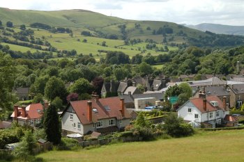
Hathersage
is a small village on the edge of Derbyshire. The hiking club normally book
a bunkhouse of some sort but on this occasion, we stayed at the North Lees
campsite just below Stanage Edge. It's a beautiful setting with spectacular
views, a half an hour walk into town. There is a short-cut that takes one to
the back of a medieval church, else it is a case of taking the way one came
in i.e. down
Birley Lane
passed a pretty little farmhouse, especially in summer, when the garden is
in bloom, back to where it forks out of Cogger's Lane down to Jagger's Lane.
Because of the scenery of the Hope and Derwent valleys, literary
connections, and easy access by train, or road from Sheffield and
Manchester, Hathersage is a popular tourist destination.
Although the
Hope Valley
appears to be a single valley, the name of the river changes several times.
The head of the valley lies below Mam Tor at Castleton (also one of our
favourite destinations). From here, the Peakshole Water flows to Hope, where
it enters the lower reaches of the River Noe, which has flowed from
Edale
(the start of the Pennine Way walk). The Noe then flows to Bamford, where it
enters the River Derwent which has travelled about ten miles from Bleaklow.
The valley is now technically the Derwent Valley, but the term "Hope Valley"
is still used as the Derwent flows through Hathersage, Grindleford and
Calver. By the time the Derwent reaches Baslow, the term "Hope Valley" is no
longer applicable.
Hathersage
lies on the north bank
of the River Derwent in the Hope Valley, approximately 10 miles west of
Sheffield. In fact our walk took us to within sight of the city, in the
direction of
Ladybower
Reservoir,
a large Y-shaped reservoir in
the Upper Derwent Valley. The water is used primarily for river control and
to compensate for the water retained by the upper two dams, but water can
also be fed into the drinking water system, however this is unusual as the
water must be pumped to treatment works rather than using gravity flow like
in the other two reservoirs, increasing costs. It is hard to believe that
this beautiful part of the Peak District was once associated with one of the
most dangerous and daring attacks of the Second World War. The reservoirs in
the Upper Derwent Valley are most famous for the fact that they were used by
617 Squadron, ‘the Dambusters’, to practice their raids prior to their
mission to the Ruhr Dams in Germany.
Hathersage
has a medieval church with a
stained glass window, which had been removed from Derwent Chapel, before it
was submerged under the Ladybower Reservoir. There are local claims to links
with the Robin Hood story. Stones in the churchyard mark what is known as
the grave of Little John. Robin is said to have used Robin Hood’s Cave, on
Stanage Edge above the village, as a hideaway. In 1845 Charlotte Bronte
stayed at the Hathersage vicarage, while she was writing Jane Eyre and many
of the locations mentioned in her novel match locations in Hathersage, the
name Eyre being that of a large extended family of landed gentry in that
part of Derbyshire. In the mid-eighteenth century, Hathersage was famous for
its brass buttons. In 1566, Christopher Schutz, a German immigrant had
invented a process for drawing wire and set up a works in Hathersage.
Stanage
Edge, or simply Stanage (from "stone edge") is a gritstone escarpment,
famous as a location for rock climbing. The northern part of the edge
forms the border between the High Peak of Derbyshire and Sheffield in
Yorkshire. Its highest point is High Neb at 458 metres above sea-level.
Stanage is a magnet for climbers and ramblers in addition to runners. The
Stanage Struggle is a popular local fell race that starts in nearby
Hathersage and rises to High Neb before returning to the village 500 ft
below.
|